New wikiloops feature preview : the members map
Page 1 of 2: 12
SUPPORTER
Posts: 2953
Joined: 30 dic 2010
I'll admit: I am a little excited :D
It has been thought about for long and by many,
and when KellsBells brought it up once more a few weeks ago (alongside the dark mode),
I felt tempted to give the member map a try.
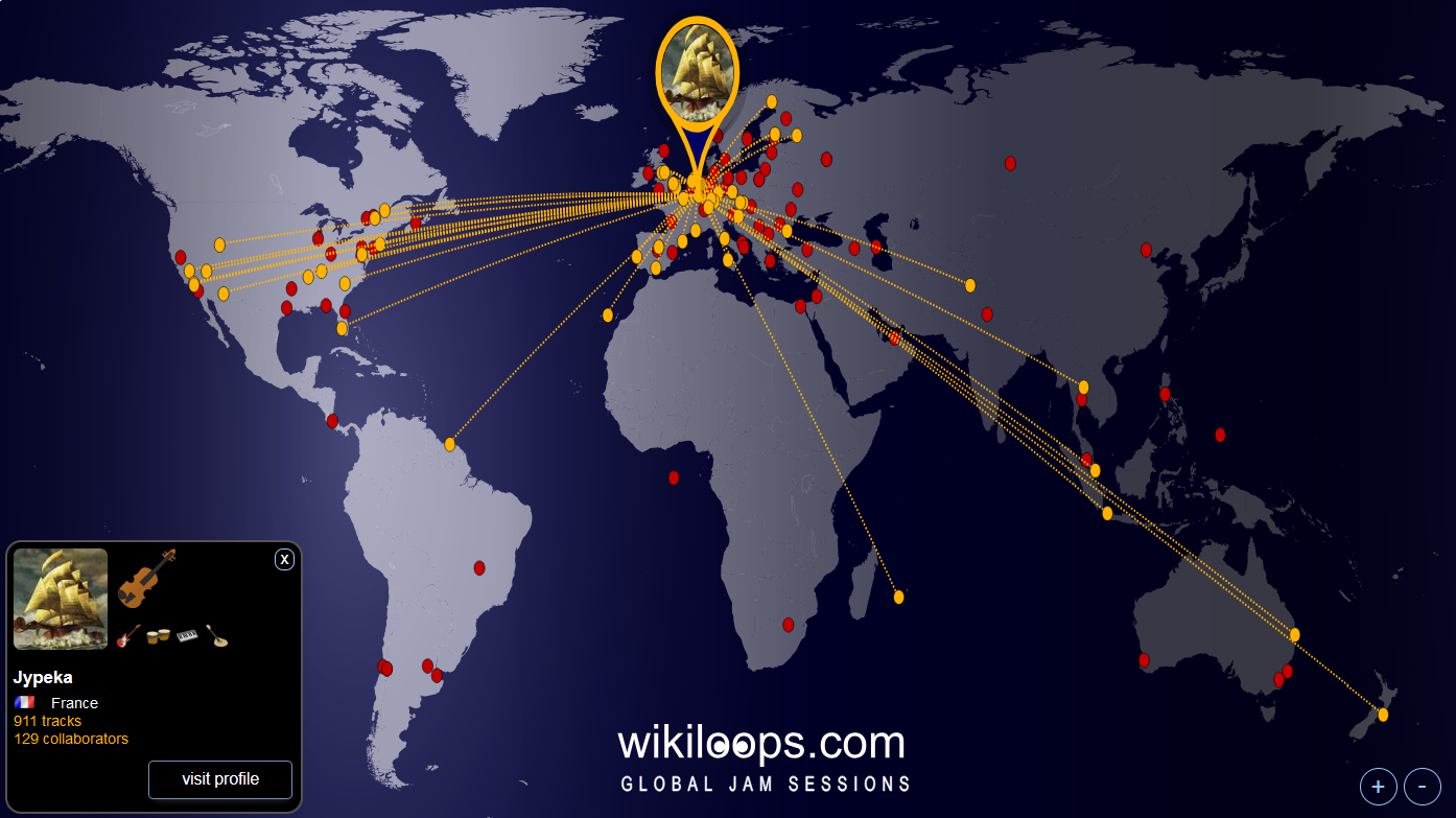
So, today I'll share a first preview with you -
mind: this is a work in progress!
A full-screen version can be viewed here:
https://www.wikiloops.com/worldMapPreview.html
Let me add a bit of explanation on the current state of the map,
most importantly how the currently displayed choice of members came about,
and what you can do to see yourself appear on that map.
If someone feel like they do NOT want to appear, this would be a great time to let me know as well :)
Okay, so, I had quite a bit of hassle to get the location placement half-ways correct. This is not trivial at all & took me a bit of deep dive into the science of map projections.
To have some test data, I generated a list of country coordinates for each "flag" one can choose on wikiloops.
That is a good start, but it also places all users from one country onto one single location, which is not what we are going for.
So, I took the freedom to look up some more individual coordinates of members who had revealed a bit more about their locations on their user profiles - if you feel badly misplaced because i choose the wrong city, here are my apologies!
Of course you will be able to edit your own coordinates once the feature goes live,
this is the test phase, right?
Now, if you do not spot yourself on the map right now, then this can be due to three reasons:
1st: your "dot" is hidden, because you have not picked a flag on wikiloops
2nd: your "dot" is hidden, because the fallback position for your country is blocked by someone else
3rd: right now, the map is limited to showing a max of 1000 users, and chooses those with the most uploads - if you have less than 16 uploads, you will currently be excluded by that filter (this is subject to change)
If you care, let me know what you think so far, and send me your decimal geolocation coordinates if you like to :)
For example:
Coordinates of Mexico City in decimal degrees would be Latitude: 19.4284700° and Longitude: -99.1276600°
You can look them up online, the tool I have been using is https://dateandtime.info/citycoordinates.php?id=3530597
This has been a sh*tload of work, but I hope you agree the result is promising.
To be honest, this interactive map, and especially the network connections that appear are displaying one of wikiloops qualities in a new telling way... I do like that.
Whatcha'll think?
It has been thought about for long and by many,
and when KellsBells brought it up once more a few weeks ago (alongside the dark mode),
I felt tempted to give the member map a try.
So, today I'll share a first preview with you -
mind: this is a work in progress!
A full-screen version can be viewed here:
https://www.wikiloops.com/worldMapPreview.html
Let me add a bit of explanation on the current state of the map,
most importantly how the currently displayed choice of members came about,
and what you can do to see yourself appear on that map.
If someone feel like they do NOT want to appear, this would be a great time to let me know as well :)
Okay, so, I had quite a bit of hassle to get the location placement half-ways correct. This is not trivial at all & took me a bit of deep dive into the science of map projections.
To have some test data, I generated a list of country coordinates for each "flag" one can choose on wikiloops.
That is a good start, but it also places all users from one country onto one single location, which is not what we are going for.
So, I took the freedom to look up some more individual coordinates of members who had revealed a bit more about their locations on their user profiles - if you feel badly misplaced because i choose the wrong city, here are my apologies!
Of course you will be able to edit your own coordinates once the feature goes live,
this is the test phase, right?
Now, if you do not spot yourself on the map right now, then this can be due to three reasons:
1st: your "dot" is hidden, because you have not picked a flag on wikiloops
2nd: your "dot" is hidden, because the fallback position for your country is blocked by someone else
3rd: right now, the map is limited to showing a max of 1000 users, and chooses those with the most uploads - if you have less than 16 uploads, you will currently be excluded by that filter (this is subject to change)
If you care, let me know what you think so far, and send me your decimal geolocation coordinates if you like to :)
For example:
Coordinates of Mexico City in decimal degrees would be Latitude: 19.4284700° and Longitude: -99.1276600°
You can look them up online, the tool I have been using is https://dateandtime.info/citycoordinates.php?id=3530597
This has been a sh*tload of work, but I hope you agree the result is promising.
To be honest, this interactive map, and especially the network connections that appear are displaying one of wikiloops qualities in a new telling way... I do like that.
Whatcha'll think?
+15
SUPPORTER
Posts: 902
Joined: 4 feb 2012
Well it's pretty and interesting and I can imagine it was a sh*tload of work for you Dick, but I'm not sure of the reason for it, am I missing something or am I just a cynical Debbie Downer ? :o
the t.bone Ovid System CC 100
Condenser Clip Microphone for Ovid System

49 €
iThis widget links to Thomann, our affiliate partner. We may receive a commission when you purchase a product there.
Visit Shop
SUPPORTER
Posts: 2953
Joined: 30 dic 2010
Shamika wrote:
am I missing something?
am I missing something?
Makes me wonder:
have you hazarded to click on one of the red dots?
the whole thingy has not been tested on mobile/touch much, btw,
so,
if you don't get to see a map at all,
please try it from some desktop device, that should work.
+1
Member
Posts: 281
Joined: 30 gen 2021
Cool!
I like the web connections, good fun. I must be hidden, where/when can we enter co-ordinates?
I like the web connections, good fun. I must be hidden, where/when can we enter co-ordinates?
+1
SUPPORTER
Posts: 2953
Joined: 30 dic 2010
Just send the coordinates to me by PM for now,
I'll add the option to set them in your profile settings eventually, but that may take a little time until it shows up.
I'll add the option to set them in your profile settings eventually, but that may take a little time until it shows up.
+1
SUPPORTER
Posts: 105
Joined: 23 ago 2021
Cool stuff. Thanks for putting in the effort.
Member
Posts: 62
Joined: 26 mag 2015
Very exciting to see who your musical neighbors may be and where/who in the world you have created music with! Really shows off the impact of global jamming! Thank you so much for always trying new features and putting in the work to keep this site evolving and running smooth. We appreciate you! ♥️
+2

SUPPORTER
Posts: 44
Joined: 13 giu 2017
Excellent Richard, I didn't think I had traveled so much :)
Me who hates flying :D
Jypeka attached the following image:
Me who hates flying :D
Jypeka attached the following image:
+4
Harley Benton G112 Celestion V30
Cabinet for Electric Guitar

169 €
iThis widget links to Thomann, our affiliate partner. We may receive a commission when you purchase a product there.
Visit Shop
Member
Posts: 281
Joined: 30 gen 2021
Dick wrote:
Just send the coordinates to me by PM for now,
I'll add the option to set them in your profile settings eventually, but that may take a little time until it shows up.
I'll wait rather than delay you with more tedious inputting stuff!Just send the coordinates to me by PM for now,
I'll add the option to set them in your profile settings eventually, but that may take a little time until it shows up.
A small unconnected thing I was reminded off when I clicked your link. Every site I use apart from this one opens links in new tabs/pages leaving the original where it was. It would be nice if wikiloops could do the same, sometimes it's a long way back.
and
If I follow an alert to a post, it takes me to the first post of the thread, not to the post. Thanks, I'll stop now - wrong thread.
+1
SUPPORTER
Posts: 538
Joined: 4 lug 2020
I feel like Spider Man:D
Would be cool to have the option to add the graphic to part of your profile.
[img]https://rookiegrower.com/wp-content/uploads/2025/01/screenshot_20250126_095117_samsung-internet8731086238613715023-scaled.jpg[/img]
Would be cool to have the option to add the graphic to part of your profile.
[img]https://rookiegrower.com/wp-content/uploads/2025/01/screenshot_20250126_095117_samsung-internet8731086238613715023-scaled.jpg[/img]
+5
SUPPORTER
Posts: 2953
Joined: 30 dic 2010
thanks for your feedback & signs of appreciation, means a lot to me :)
I have added some more locations tonight as they hit my inbox (don't hesitate!) and will proceed tweaking the map thing.
I have also considered it might be a nice to have on ones profile, there are a lot of options on the table once this works.
I also looked into displaying a single tracks participants on that map (kinda similar to what we have on the radio)... so, I'll be aiming to make it as versatile as possible.
Would anyone favor to have a sample track accessible from each location the map?
Or, how about having some sort of short-statement-slot for things like "strictly for the fun of it" or
"farming kangaroos" or
"open for requests" or whatever else one feels like adding to ones location bubble ?
One flaw I'll have to fix is the zooming, which is still too limited - don't know why all wikilooopers from brazil have to live in one city... that calls for some solution ;)
+4
SUPPORTER
Posts: 331
Joined: 19 mar 2022
Very cool, love it.
In the meantime, could someone send a search and rescue vessel to the atlantic ocean, just a couple of hundred miles south of ivory coast? Seems that Piper is stranded there, unless I missed something on the news and Scotland has taken over new territories.
In the meantime, could someone send a search and rescue vessel to the atlantic ocean, just a couple of hundred miles south of ivory coast? Seems that Piper is stranded there, unless I missed something on the news and Scotland has taken over new territories.
+2
Harley Benton G112 Celestion V30
Cabinet for Electric Guitar
169 €
iThis widget links to Thomann, our affiliate partner. We may receive a commission when you purchase a product there.
Visit Shop
SUPPORTER
Posts: 538
Joined: 4 lug 2020
Dick wrote:
Would anyone favor to have a sample track accessible from each location the map?
Or, how about having some sort of short-statement-slot for things like "strictly for the fun of it" or
"farming kangaroos" or
"open for requests" or whatever else one feels like adding to ones location bubble ?
Would anyone favor to have a sample track accessible from each location the map?
Or, how about having some sort of short-statement-slot for things like "strictly for the fun of it" or
"farming kangaroos" or
"open for requests" or whatever else one feels like adding to ones location bubble ?
a sample track would be interesting, would it be a sample track which is unique to every connection? each "connection" to a looper would provide a sample track with that looper?
+1
SUPPORTER
Posts: 2118
Joined: 27 set 2014
Fun feature Richard :) I saw we had a user on an island below west Africa, I clicked on it and was surprised it'S Piper from Scotland. Long way from home :)
+3

SUPPORTER
Posts: 945
Joined: 14 feb 2018
Fun feature indeed - and I also like the dark mode a lot, especially in the evenings!
That web page you've mentioned didn't show our little city here in Hessen, Germany, but from your map I saw some nearby fellow 'loopers. I looked up the coordinates of our place (to the exact house) on openstreetmap.org, for those who can't find their towns or villages as well, just right-click on your house and choose "Show address" to see the decimal coordinates in case you're interested & willing to share those.
That web page you've mentioned didn't show our little city here in Hessen, Germany, but from your map I saw some nearby fellow 'loopers. I looked up the coordinates of our place (to the exact house) on openstreetmap.org, for those who can't find their towns or villages as well, just right-click on your house and choose "Show address" to see the decimal coordinates in case you're interested & willing to share those.
SUPPORTER
Posts: 245
Joined: 1 gen 2017
I am fan of the members map. Soon we can meet WL friends in real life too - e.g. in the lunch break to have a small live jamming
+1
Member
Posts: 62
Joined: 26 mag 2015
hartmut wrote:
I am fan of the members map. Soon we can meet WL friends in real life too - e.g. in the lunch break to have a small live jamming
I am fan of the members map. Soon we can meet WL friends in real life too - e.g. in the lunch break to have a small live jamming
I actually found out through this website that I was making music with someone who lives just 20 miles from me. Never would have known them or made the music if it wasn't for the Loops! Love the effect this map has at truly visualizing a Global Jam!
+5
SUPPORTER
Posts: 2953
Joined: 30 dic 2010
First thing: you might need to dump your cache or reload the page with ctrl+F5 to get to see the latest improvements! please do!
Okay, so, the rescue team went out and saved the lost scots on that "island". That position is the infamous 0/0 coordinate btw (aka system does not find a location), not sure there is any island or a floating monument...
I've also added a whole bunch of dots, but mind:
the map is still displaying only 10% of the ever-active members of wikiloops, the rest has not been "located" yet.
As far as the zooming is concerned, I've improved that a bit, but I still need to adjust the size of the dots a little.
Depending on whether you are on a touch device or not, you'll have a hard time ever hitting one of those dots, that's another evening to work that out...
I did disable the connection lines display as soon as you are zooming in, which makes the close-up views less cluttered (many connection lines would cover too many dots on their ways, they only make sense if you see the whole map, IMHO)
Last but not least, I've added the "auto animation" feature, you can start that by clicking on that shuffle button in the bottom right corner, and it will "simply" animate over the networks and move from one to the other.
That's fun to sit and watch, and -depending on the surroundings- that animation might as well start by itself so people get a hang of what this map is without needing to click on some dot first...
Which leads me back to the question of where this thing will appear in the long run.
I'll tell you the truth and say that I believe it is going to sit right on the homepage of wikiloops, as it displays the global network(s) so well.
Hence the idea to include a player into the map to let people check out peoples music right from the map.
That is not saying one can't have their own map on their profile as well, if that seems desirable.
I was tempted to follow Nicks suggestion to turn the map into a search interface, where one could select rootshells location, to then ctrl+click on one of his connected network dots,
to then get to see a track where the two selected folks collaborated... but that's one of those extra nerdy features that only very few people would discover, so, excuse me for not doing that.
I've been looking at this map for a few weeks now, and I can tell you, it does change ones idea of wikiloops, and gives one a different feeling when scanning the online users panel.
Some of you people are simply unbelieveably far away, some of these countries are smaller or larger than one had in mind... its hard to describe, but it has a strong effect.
Maybe that's also because it makes me realize my little idea here went around, from Floisdorf, Germany to Hawai, around the back to Australia and back... amazing times, when all you need to spread some idea is a windows 2k computer, some drum beats and, well, dedication.
I feel this might also be the right moment to mention that you are all witnessing one of the merits of the AI age here, this whole map feature would have taken a team of several people weeks to code a few years ago, now it's something I can do without being a geographer, graphic designer or coding wizard... take it as good news, one can achieve a lot of things a lot easier now, and here we have a positive example to look at.
I have been wondering wether the euro-centric worldmap might look odd to those of you who are used to world maps with either the amiericas or asia are in the center - it is the one that looks "normal" to us europeans, and, well, I hope it does not create any odd feelings - let me know if it does...
I'm still wondering to include a kangaroo-button, so the aussies can view the map upside down :P (sorry, had to...)
Let me know what crosses your mind & sorry for the long read ;)
+6
the t.bone Ovid System CC 100
Condenser Clip Microphone for Ovid System
49 €
iThis widget links to Thomann, our affiliate partner. We may receive a commission when you purchase a product there.
Visit Shop
SUPPORTER
Posts: 300
Joined: 2 giu 2018
So cool, the zoom feature works great, thanks for all the work involved in bringing wikiworld to us :W
+1

SUPPORTER
Posts: 6
Joined: 15 giu 2021
Interesting to see the world map...but is there a button on WL to tap to get to the map now and then...or do I have to save this (https://www.wikiloops.com/worldMapPreview.html) and type in each time.
+1
Page 1 of 2: 12
wikiloops online jamsessions are brought to you with friendly
support by:

Wikiloops is my Music Wonderland, it's only take a few days till you get addicted! I'm so lucky to finally found this place.
aleonz